| Excerpts from the National Hurricane Center advisories:
 |
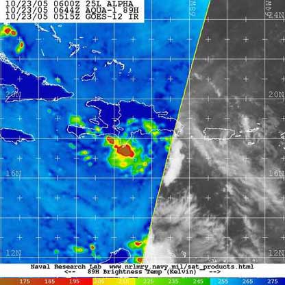
Tropical Storm Alpha - Sunday Oct 23 2005 - 7:44am Haiti Time
Infrared Satellite image courtesy of NRL Marine Meteorology Division |
 |
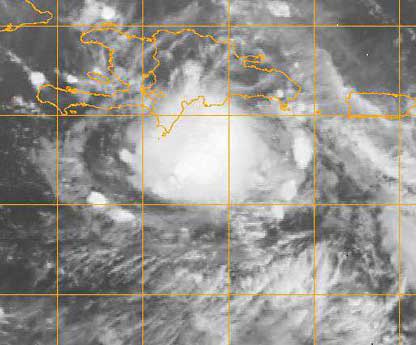
Tropical Storm Alpha - Oct 22 2005 - 10:15pm Haiti Time
Infrared Satellite image courtesy of NRL Marine Meteorology Division |
000
WTNT35 KNHC 231137
TCPAT5
BULLETIN
TROPICAL STORM ALPHA INTERMEDIATE ADVISORY
NUMBER 4A
NWS TPC/NATIONAL HURRICANE CENTER MIAMI FL
8 AM EDT SUN OCT 23 2005
...ALPHA MADE LANDFALL NEAR THE TOWN OF BARAHONA IN THE DOMINICAN REPUBLIC...
A TROPICAL STORM WARNING REMAINS IN EFFECT FOR THE ENTIRE COASTLINES OF THE DOMINICAN REPUBLIC AND HAITI.
A TROPICAL STORM WARNING REMAINS IN EFFECT FOR THE TURKS AND CAICOS AND FOR THE SOUTHEASTERN BAHAMAS.
FOR STORM INFORMATION SPECIFIC TO YOUR AREA...INCLUDING POSSIBLE INLAND WATCHES AND WARNINGS...PLEASE MONITOR PRODUCTS ISSUED BY YOUR LOCAL WEATHER OFFICE.
SATELLITE IMAGES AND SURFACE OBSERVATIONS INDICATE THAT THE CENTER OF ALFA MADE LANDFALL NEAR THE TOWN OF BARAHONA IN THE DOMINICAN REPUBLIC. AT 8 AM EDT...1200Z...THE CENTER OF THE TROPICAL STORM WAS LOCATED NEAR LATITUDE 18.4 NORTH... LONGITUDE 71.4 WEST OR ABOUT 25 MILES... 35 KM...WEST-NORTHWST OF THE CITY OF BARAHONA IN THE DOMINICAN REPUBLIC.
ALPHA IS MOVING TOWARD THE NORTHWEST NEAR 14 MPH ...22 KM/HR...AND
THIS MOTION IS EXPECTED TO CONTINUE UNTIL LANDFALL IN THE NEXT HOUR OR SO. A TURN TO THE NORTH-NORTHWEST IS EXPECTED OVER THE NEXT 24 HOURS.
MAXIMUM SUSTAINED WINDS ARE NEAR 50 MPH...85 KM/HR...WITH HIGHER
GUSTS. ALPHA IS EXPECTED TO WEAKEN RAPIDLY AND COULD DISSIPATE OVER THE MOUNTAINOUS TERRAIN OF HISPANIOLA.
TROPICAL STORM FORCE WINDS EXTEND OUTWARD UP TO 45 MILES ... 75 KM FROM THE CENTER. A METEOROLOGICAL STATION IN THE CITY OF BARAHONA
REPORTED SUSTAINED WINDS OF 50 MPH...85 KM/HR AS THE CENTER OF ALPHA MOVED NEARBY.
ESTIMATED MINIMUM CENTRAL PRESSURE IS 1000 MB...29.53 INCHES.
THE STORM IS EXPECTED TO PRODUCE TOTAL RAIN ACCUMULATIONS OF 4 TO 8 INCHES OVER MUCH OF HISPANIOLA...WITH POSSIBLE ISOLATED MAXIMUM AMOUNTS OF 15 INCHES OVER MOUNTAINOUS TERRAIN. THESE RAINS COULD PRODUCE LIFE-THREATENING FLASH FLOODS AND MUD SLIDES.
REPEATING THE 8 AM EDT POSITION...18.4 N... 71.4 W. MOVEMENT TOWARD...NORTHWEST NEAR 14 MPH. MAXIMUM SUSTAINED WINDS... 50 MPH. MINIMUM CENTRAL PRESSURE...1000 MB.
THE NEXT ADVISORY WILL BE ISSUED BY THE NATIONAL HURRICANE CENTER AT 11 AM EDT.
FORECASTER AVILA
$$
000
WTNT45 KNHC 230228 TCDAT5
TROPICAL STORM ALPHA DISCUSSION NUMBER 3
NWS TPC/NATIONAL HURRICANE CENTER MIAMI FL
11 PM EDT SAT OCT 22 2005
HALF OF AN EYEWALL-LIKE FEATURE WAS VISIBLE ON THE SAN JUAN RADAR AS ALPHA WAS MOVING OUT OF RANGE A COUPLE HOURS AGO...WITH SIMILAR ROTATION BRIEFLY OBSERVED WITHIN THE VERY COLD TOPS OF ITS CORE CONVECTION. ALTHOUGH THE DVORAK INTENSITY ESTIMATES WERE NO HIGHER THAN 35 KT AT 00Z...THE RADAR SIGNATURE SUGGESTS THAT ALPHA COULD HAVE A VERY SMALL CORE OF STRONGER WINDS AND THE ADVISORY INTENSITY IS BEING RAISED TO 45 KT. A LITTLE MORE STRENGTHENING IS POSSIBLE IN THE 6 OR SO HOURS BEFORE ALPHA REACHES HISPANIOLA. ALPHA'S SMALL
CIRCULATION SHOULD BE SIGNIFICANTLY DISRUPTED BY THE MOUNTAINS OF
HISPANIOLA...AND IS IS POSSIBLE THAT THE CYCLONE WILL DISSIPATE AS
IT CROSSES THE ISLAND. ASSUMING THAT IT SURVIVES INTO THE
ATLANTIC...ALPHA WILL FIND ITSELF IN INCREASING SOUTHERLY FLOW AS
IT IS OVERTAKEN BY THE CIRCULATION OF HURRICANE WILMA IN ABOUT 36
HOURS...AND EVEN THOUGH THE WIND SHEAR IS NOT EXPECTED TO BE STRONG
THE CYCLONE WILL PROBABLY HAVE DIFFICULTY MAINTAINING A CLOSED
SURFACE CIRCULATION. THEREFORE THE OFFICIAL FORECAST CALLS FOR THE
CIRCULATION TO DISSIPATE WITHIN 48 HOURS.
THE INITIAL MOTION IS 305/10. ALPHA IS NEARING THE SOUTHWEST EDGE
OF THE SUBTROPICAL RIDGE. AS THE LARGE CIRCULATION OF HURRICANE
WILMA APPROACHES OVER THE NEXT 24 HOURS...ALPHA IS EXPECTED TO TURN
NORTHWARD AND ACCELERATE. THE OFFICIAL FORECAST IS A LITTLE TO THE
LEFT AND SLOWER THAN THE GLOBAL MODEL GUIDANCE ON THE ASSUMPTION
THAT THE SURFACE AND UPPER CIRCULATIONS MAY DECOUPLE DURING THE
INTERACTION WITH THE TERRAIN OF HISPANIOLA.
ALPHA HAS THE POTENTIAL TO BE A SIGNIFICANT RAINFALL/FLOODING EVENT
OVER HISPANIOLA...WITH A STRONG LIKLIHOOD OF LIFE-THREATENING FLASH
FLOODS AND MUD-SLIDES.
FORECASTER FRANKLIN
FORECAST POSITIONS AND MAX WINDS
INITIAL 23/0300Z 17.7N 70.1W 45 KT
12HR VT 23/1200Z 18.9N 71.5W 30 KT...INLAND
24HR VT 24/0000Z 22.0N 72.5W 30 KT...OVER WATER
36HR VT 24/1200Z 26.0N 73.0W 30 KT...DISSIPATING
48HR VT 25/0000Z...ABSORBED WITHIN CIRCULATION OF WILMA
------------------------------------------------------------------------------------------------
WTNT35 KNHC 222102 TCPAT5
BULLETIN TROPICAL STORM ALPHA
ADVISORY NUMBER 2
NWS TPC/NATIONAL HURRICANE CENTER MIAMI FL
5 PM EDT SAT OCT 22 2005
...ALPHA BECOMES THE TWENTY-SECOND NAMED STORM OF THE SEASON AND BREAKS THE ALL-TIME RECORD FOR THE MOST ACTIVE SEASON ON RECORD...
AT 5 PM EDT...THE GOVERNMENT OF THE DOMINICAN REPUBLIC HAS ISSUED A TROPICAL STORM WARNING FOR THE ENTIRE NORTHERN COAST. A TROPICAL STORM WARNING IS NOW IF EFFECT FOR THE ENTIRE COASTLINE OF THE DOMINICAN REPUBLIC.
AT 5 PM EDT...THE GOVERNMENT OF THE BAHAMAS HAS UPGRADED THE TROPICAL STORM WATCH TO A TROPICAL STORM WARNING FOR THE SOUTHEASTERN BAHAMAS...AND FOR THE TURKS AND CAICOS.
A TROPICAL STROM WARNING REMAINS IN EFFECT FOR THE ENTIRE COASTLINE OF HAITI.
FOR STORM INFORMATION SPECIFIC TO YOUR AREA...INCLUDING POSSIBLE INLAND WATCHES AND WARNINGS...PLEASE MONITOR PRODUCTS ISSUED BY YOUR LOCAL WEATHER OFFICE.
AT 5 PM EDT...2100Z...THE CENTER OF TROPICAL STORM ALPHA WAS LOCATED NEAR LATITUDE 17.0 NORTH... LONGITUDE 68.9 WEST OR ABOUT 210 MILES... 335 KM... WEST-SOUTHWEST OF SAN JUAN PUERTO RICO AND ABOUT 125 MILES... 200 KM...SOUTH-SOUTHEAST OF SANTO DOMINGO IN THE DOMINICAN REPUBLIC.
ALPHA IS MOVING TOWARD THE NORTHWEST NEAR 15 MPH ...24 KM/HR...AND THIS MOTION IS EXPECTED TO CONTINUE FOR THE NEXT 24 HOURS AND SHOULD BRING THE CENTER OF ALPHA TO THE COAST OF HISPANIOLA LATE TONIGHT OR EARLY SUNDAY MORNING.
MAXIMUM SUSTAINED WINDS ARE NEAR 40 MPH... 65 KM/HR...WITH HIGHER GUSTS. SOME STRENGTHENING IS POSSIBLE BEFORE THE CENTER OF THE TROPICAL STORM REACHES THE SOUTHERN COAST OF HISPANIOLA.
TROPICAL STORM FORCE WINDS EXTEND OUTWARD UP TO 45 MILES... 75 KM FROM THE CENTER. ESTIMATED MINIMUM CENTRAL PRESSURE IS 1005 MB...29.68 INCHES. THE STORM IS EXPECTED TO PRODUCE TOTAL RAIN ACCUMULATIONS OF 4 TO 8 INCHES OVER MUCH OF HISPANIOLA...WITH POSSIBLE ISOLATED MAXIMUM AMOUNTS OF 12 INCHES.
THESE RAINS COULD PRODUCE LIFE-THREATENING FLASH FLOODS AND MUD SLIDES.
REPEATING THE 5 PM EDT POSITION...
17.0 N... 68.9 W. MOVEMENT ...STATIONARY.
MAXIMUM SUSTAINED WINDS... 40 MPH.
MINIMUM CENTRAL PRESSURE... 1005 MB.
AN INTERMEDIATE ADVISORY WILL BE ISSUED BY THE NATIONAL HURRICANE CENTER AT 8 PM EDT FOLLOWED BY THE NEXT COMPLETE ADVISORY AT 11 PM EDT.
FORECASTER MAINELLI/KNABB
|


